About DVDs: "...why not place some audio ads on CDs that people cannot skip over. When you start up your computer, you have to sit there and watch four ads before you get to your desktop. When you get in your car in the morning, the transmission won’t shift into Drive until you have listened to three messages about the latest GM cars you could be driving. Every time you hit the snooze on your alarm clock, you have to listen to a McDonalds breakfast commercial before it turns off. Before you’re refrigerator opens, you have to listen to the latest Pepsi ad. Want to place a call on your cell? You have to hear two ads first."
About the Future: "Due to a glitch in Windows Vista, Microsoft CEO Steve Ballmer will mix up his notes at PDC ‘06 and declare: “Developers, developers, developers….We’re going to <beeping/> bury those guys!” Nineteen will leave on stretchers with furniture-related injuries."
Thursday, December 29, 2005
Sunday, December 11, 2005
Sunday, November 27, 2005
Why I Fly (chapter 9)
We have a friend whose parents live on Camano Island. They have an older Gateway laptop that had over the years become sluggish. The computer had made several visits to the shop but the problem had never been resolved to their satisfaction. On it, they run Windows 2000, AOL 9.0 and every add-on AOL blocker / filter / spyware / autoconnect / dialer piece of software available, as well as Symantec 2005 Internet suite, and that is just the start-up.
Our friend suggested the family come up to visit with her, her eight year-old son, and her parents. They have a comfortable home on the west side of the island over looking the passage between Camano and Whidbey Islands. It was a warm October day; Sandra sat on the deck, soaked in the sun, and we all ate a lovely lunch. The kids played in the yard. The boys played pirates with wooden swords while the girls chased after them.
Meanwhile I worked on their laptop. It turns out the trouble is that it had “only” 128 MB of RAM. This is bad because just the startup process loads over 200 MB of programs. During the initial program load, the main memory fills, and it starts swapping programs out to the paging file, but many of those programs are vying for their slice of the CPU’s attention, and they are also swapping back in, delaying the loading of the next program. From power on to a useful state can take about 30 minutes.
I found another 128 MB of memory on ebay for $25. I also knew that my friend’s son had been hoping for an airplane ride, and there is a small airstrip on the island, so with a bit of coordination, I could fly up there, catch a ride to their house, install the memory. It would probably be faster to drive there than it would be to go to Paine Field, get a car-seat out of the truck, preflight the plane, put the car-seat into the plane, buckle in, taxi out, and fly, and then reverse the process at the other end. But if I flew the plane I could take my friend’s son for a ride.
The airstrip is the home of Steve Knopp, a respected pilot and mechanic. Steve built the engine that is in my plane. I use the term “airstrip” in this case with caution. If I were to rank the airports I’ve landed at by “most like what non-pilots think an airport is,” at the top, Camino is second from the bottom, just before a grass field in the mountains. The FAA list these specifications for the runway: 1750 feet long, 24 feet wide, 145 feet above sea level, asphalt in good condition. Yeaaaaah, riiiiight.
Imagine this: On the north side of the island there is a tide-flat up against 135 foot cliff covered with bushes and topped with trees. From this mass of brush and trees, a 75-foot wide notch has been cut, exposing a strip of asphalt perpendicular to the cliffs edge. The terrain and asphalt continues to slope up to the south. The persistent shade from the trees on both sides, the moisture of the Pacific Northwest sea air, and the northern exposure of the slope result in an excellent place for moss to grow. About the first third of the up sloping runway has a patchwork selection of this green, slippery, fuzzy moss shielding the asphalt.
From there the runway kind of levels out and then ends at the short barbed wire fence that separates the airport from the ditch on the edge of the east west road. Power-line poles stick up like goal posts the north end of the runway, where the power-line is diverted down underground for the width of the approach.
When you are landing to the south, you line up out over the water to fly towards the runway, reducing power and descending in to the face of the cliff. This alone is a bit troubling. As you approach the runway you have to keep the airplane above the trees at the cliffs edge, and then sink towards the unmarked threshold of the runway. Because the runway slopes up, you have to transition the airplane to not just descending but almost to a power off climb to keep the moss covered asphalt from jumping up and smacking the wheels of the plane.
Once contact has been made with the ground, applying the brakes can result in asymmetric braking on the patch of moss under one wheel and asphalt under the other, and 20 feet later the moss and asphalt trade sides. Using the brakes on this end of the runway varies from worthless to risky. I don’t use the breaks until I am past the moss.
This can leave precious little space to slow the airplane from 80 mph to stopped before encountering the fence, ditch, and road on the north end.
Landing from the other end has its challenges as well. Lining up to fly over the traffic on the road, between the power poles, over the short fence and on to the runway, and then stopping on the downward sloping slippery moss towards the cliff’s edge creates some excitement.
I don’t recommend this airstrip to new pilots. But with adequate understanding and planning, the challenges are converted into a rewarding accomplishment. Dozens of airplanes use this strip each week.
It has been foggy around here for about a week -- very odd. The fog finally broke making a chance for me to take the memory up to the island. I took the my boys and youngest daughter with me.
As we flew over the mouth of the Skagit River, my boys and I discussed the muddy fall waters flowing from the river into the Puget Sound. There was a distinct arcing line that separated the silt-laden waters of the river from the blue-green waters of the sound.
When we reached the airstrip a few moments later the winds were out of the southwest, meaning I would land to the south into the cliff and correct for the bit of crosswind at the same time.
My four year old daughter judged my landing as “Bad landing, dad!” Some how, assessing the quality of my landings became a family tradition. It had been a long time since one had been rated poorly, a trend I was quite proud of. But this time the judges robbed me. Considering the degree of difficulty and technical merit, I was thought the score was much too low.
The computer’s memory install went without a hitch. There was another error with a corrupted file that resulted in the need to uninstall and reinstall Symatec, but the short winter days forced me to head back to the plane before completing the task.
We all went back to the airstrip and the boys loaded in to the plane for the big ride. I taxied back to the north end of the runway and made my take off run up hill to the south. We were up by the middle of the runway and banking the plane so mom and grandpa could be seen out the right hand window, watching us depart.
I circled over the north coast of the island and followed it around to west side where their home is. I radioed Whidbey approach to let them know I would be maneuvering under their airspace, but planning to stay out of it. I did this for three reasons. First I wanted them to know I was there and to be aware of us, second I wanted to have established communication in case I inadvertently flew into their airspace, and last but most important if we had to make an off airport landing, my only choice during this high tide was the water, and I wanted to already be talking to the rescue team before the splash-down.
I stayed low below the Whidbey airspace. We circled their house a couple times and then dropped down to 500 feet for one last pass over the water in front of their deck. My friend’s son proclaimed he saw his Grandma on the deck. Our heading was reversed and we were pointed back at the airstrip flying north along the west side of the Island. We curved back around the shoreline to make a right-base entry into the pattern, and I stuck the plane back on the moss, and waited for the solid sections of asphalt before trying the brakes.
I swung the plane onto the taxi way and shut down the engine (oooh, another story there. In the plane our rule is that everybody’s seatbelt stays fastened until the propeller stops turning). My friend’s son bounced out of the plane ecstatic to have had the ride. He was talking several hundred words a minute to tell his mom every detail. His mom, being a pilot too, knowingly smiled and exclaimed “Tell me all about it!”
The words came from his mouth as fast as his tongue could form them and as picturesque as the vocabulary of eight year old could muster. The joy of this message was clear. He liked it, and would be looking for more in the future. His excitement was thanks enough for me.
After hugs for everyone, I loaded my family back into the plane. There was still a slight wind from the south, but after having already made two landings and one take off on this airstrip I was comfortable I could make my favorite departure. From the south end, I ran the engine up and released the brakes. Again about half way down we lifted off the asphalt. But instead of climbing, I kept the plane in ground effect and let the speed build up, following the slope of the runway down hill accelerating even more. As we reached the end, I lifted the nose of the plane enough to rise above the bushes and tree branches and we shot off the cliff between the trees and over the tide flats. This made me long for the days of open cockpits and the accompanying shouts of exhilaration.
Flying can be like crack or heroine -- it is addictive. And for those of us who are addicts, a clear day after a long series of foggy days is like our drug calling out our names. And I was not the only one hearing my name called. On the trip home, the sky was speckled with airplanes giving their respective pilots a fix of blue. On approach to Paine Field I ended up tucked between two other planes, both slightly ahead of me one to my right and one to my left. The pilot to my left decided there were too many planes headed back to the airport and he was going to fly around a bit more. He broke away to the east.
This left me to behind a slower airplane to my right. I slowed down to create space between us. And then I slowed down some more. And some more. I stretched the space out pretty well and was cleared to land behind him. As a precaution I slowed down some more, putting down 20 degrees of flaps to decrease speed and increase lift.
As I watched the airplane ahead land and make a long roll out, staying on the runway, I knew what was about to happen. As we got to about 200 feet above the ground, I was going to extend the flaps the rest of the way, but then I thought again. The pilot ahead was still on the runway, and the controller could not clear me to land as long as he was on it.
“Cessna one eight three five zulu, go around.” The controller instructed. I responded to the controller and pushed the power back in, climbing back into the sky.
I turned the plane crosswind and then downwind before getting another clearance to land. Seeing all the other planes in the pattern, I wanted to get down and clear as soon as practical, so when I was even with the end of the runway, I pulled the power off and made a gliding 180 degree turn down to the runway, stopped and off about a third of the way down the runway.
We were soon back home, safe and sound after another adventure.
Thursday, November 10, 2005
Sunday, November 06, 2005
Why I Fly (chapter 8)
Today I took Randy and his son Nathan for a flight.
I brought my youngest daughter with me to meet them at the airport a bit before 2:00 pm. I made my usual pre-flight, with Nathan following intently behind, asking about each item on the list. Some questions had easy answers, some not so easy. Things like, "How come there is only a trim-tab on one side of the airplane?" is not so easy. Where as, "Why do you drain out a little bit of gas?" is much easier.
The pre-flight revealed a small amount of water in the gas tank. This can happen when it rains a lot and some seeps in around the cap, or when the moist air inside the tank condenses and the vapor turns to liquid. Either way, the water is heavier than the gas and sinks to the bottom of the tank where a small drain allows it to be removed.
 Randy had flown with me before, so he sent Nathan up front. Randy has this really great desire to honor others in his speech and actions. This desire extends to his son as well. We strapped my daughters car seat behind the pilots seat, and Randy climbed in next to her, and Nathan buckled into the co-pilot seat.
We continued down the check-list for starting the plane until we got to my favorite part of the list -- turning the key. Before starting a plane, there is one last check to make sure everyone is clear of the propeller. I opened the window and shouted "CLEAR!" That for me is the sign that the fun is about to start. Aside from the permission to shout (when else is it considered ok to shout?) it is the official start of powered flight. For me, the process of shouting is that transition.
The sky was covered by broken clouds again today, so after looking about we decided to head southwest. These clouds would later prove to help by keeping us closer to the details of the earth as we made our tour. Once we escaped the surly bonds of earth we headed south towards the hood canal. Nathan began to point and ask questions. "Is that Whidbey?" and "Is that Hat Island?" and "Everett?" yep, yep, and yep. For a kid that grew up in Colorado, he knew his way around the Puget Sound.
And then he asked the question that changed the course of the day. "Have you ever flown over Deception Pass?"
We hung a right and headed north up the east coast of Whidbey Island. As we flew north we looked at Port Towsend, Fort Flagler, Fort Worden, and Fort Casey. Casey is the most popular of the three, but my boys and I enjoyed exploring Worden much more. We preceded north by Smith Island and NAS Whidbey up to the pass.
Deception Pass is a narrow opening between the mainland and the north end of Whidbey Island. The island extends south from there 36 miles. For tides to go in and out, the water must either pass through that narrow channel or travel 36 miles around the island. The current can get pretty aggressive. Complicating things, in the channel, there is another small island. The road builders used this small island as a pillar for the bridge by building one span from the mainland to the little island, and then a larger second span from the small island to Whidbey. They are graceful arching bridges that contrast with the rugged rocks they are built upon. There are very popular walking paths across the bridge. Flying over the pass in the plane is pretty. Walking across the pass on the bridge is breath-taking.
I often wonder what it would take to get permission to fly UNDER the bridge.
We flew OVER the bridge today.
Our eastward course took us back to the mainland and over to I-5. I gave Randy my camera to let him take pictures. They came out pretty good -- take a look.
After passing the Arlington airport, we crossed over to the east side of the freeway. Shortly after that we were talking to the tower to get our landing clearance, and the ride was over.
Time sharing the world from one of my favorite views with Randy, who searches out Divine beauty, is just one more reason why I fly.
I brought my youngest daughter
with me to meet them at the airport a bit before 2:00 pm. I made my usual pre-flight, with Nathan following intently behind, asking about each item on the list. Some questions had easy answers, some not so easy. Things like, "How come there is only a trim-tab on one side of the airplane?" is not so easy. Where as, "Why do you drain out a little bit of gas?" is much easier.The pre-flight revealed a small amount of water in the gas tank. This can happen when it rains a lot and some seeps in around the cap, or when the moist air inside the tank condenses and the vapor turns to liquid. Either way, the water is heavier than the gas and sinks to the bottom of the tank where a small drain allows it to be removed.
Randy had flown with me before, so he sent Nathan up front. Randy has this really great desire to honor others in his speech and actions. This desire extends to his son as well. We strapped my daughters car seat behind the pilots seat, and Randy climbed in next to her, and Nathan buckled into the co-pilot seat.We continued down the check-list for starting the plane until we got to my favorite part of the list -- turning the key. Before starting a plane, there is one last check to make sure everyone is clear of the propeller. I opened the window and shouted "CLEAR!" That for me is the sign that the fun is about to start. Aside from the permission to shout (when else is it considered ok to shout?) it is the official start of powered flight. For me, the process of shouting is that transition.
The sky was covered by broken clouds again today, so after looking about we decided to head southwest. These clouds would later prove to help by keeping us closer to the details of the earth as we made our tour. Once we escaped the surly bonds of earth we headed south towards the hood canal.
Nathan began to point and ask questions. "Is that Whidbey?" and "Is that Hat Island?" and "Everett?" yep, yep, and yep. For a kid that grew up in Colorado, he knew his way around the Puget Sound.And then he asked the question that changed the course of the day. "Have you ever flown over Deception Pass?"
We hung a right and headed north up the east coast of Whidbey Island. As we flew north we looked at Port Towsend, Fort Flagler, Fort Worden, and Fort Casey. Casey is the most popular of the three, but my boys and I enjoyed exploring Worden much more. We preceded north by Smith Island and NAS Whidbey up to the pass.
Deception Pass is a narrow opening between the mainland and the north end of Whidbey Island. The island extends south from there 36 miles. For tides to go in and out, the water must either pass through that narrow channel or travel 36 miles around the island. The current can get pretty aggressive.
Complicating things, in the channel, there is another small island. The road builders used this small island as a pillar for the bridge by building one span from the mainland to the little island, and then a larger second span from the small island to Whidbey. They are graceful arching bridges that contrast with the rugged rocks they are built upon. There are very popular walking paths across the bridge. Flying over the pass in the plane is pretty. Walking across the pass on the bridge is breath-taking.I often wonder what it would take to get permission to fly UNDER the bridge.
We flew OVER the bridge today.
Our eastward course took us back to the mainland and over to I-5. I gave Randy my camera to let him take pictures. They came out pretty good -- take a look.
After passing the Arlington airport, we crossed over to the east side of the freeway. Shortly after that we were talking to the tower to get our landing clearance, and the ride was over.
Time sharing the world from one of my favorite views with Randy, who searches out Divine beauty, is just one more reason why I fly.
Tuesday, November 01, 2005
Gmail feature request - intelligent addressing.
Note: While writing this I realized it is a feature needed to work around a bug.
Following the lead of Cedric and Krzysztof, I have some gmail requests too. When addressing a mail to someone with multiple addresses, it should remember the address I used most recently, and put it at the top of the hint list.
Many of my contact use mail redirection services so their address is something like "Bob [at] myVanityDomain [dot] com" which is forwarded "poluted.namepace.random.string [at] gmail [dot] com." (Here's the bug:) Connecting to this person in google talk required (not sure if it still does) the gmail address to be the primary address, or the invitation just did not work out. So now when I start typing bob's name, the gmail address appears first. I want a way for it to remember to use the other address instead.
As to my comment on Cedric's blog, I discovered that if I add something like "familyMember" into the notes of an email address, I can view my contacts, and then search for "familyMember" to get a list of all the people in my address book who are family members for group emails, but I'm still waiting for address groups or tags or something to make group mail easier.
One last thing. It does not appear to be possible to archive "sent" items. They are either sent, or deleted. Which mean that either you allow your sent folder to collect clutter, or you delete them all together.
Please?
Saturday, October 29, 2005
I just don’t get enough SPAM in my diet.
Now that I'’ve had to administer an email system (I installed Exchange over at Regal Air), I've spent a bit more time thinking about spam --– by necessity. Regal was getting their mail filtered through SeaNet, but for a myriad of reasons -- and I don'’t want to debate the choice --– we brought in Exchange. Almost immediately the users started complaining about the number of Unsolicited Commercial Email (UCE, or SPAM).
Microsoft supplies a plug-in for exchange they call the Intelligent Message Filter (IMF). This gizmo reads incoming mail, and assigns a SPAM value to it of zero to nine. Zero being the least likely to be SPAM and nine being most certain of being SPAM. I installed the plug in and started monitoring. Within a day I discovered that over half of our incoming mail was a seven or greater. I started the filter out at discarding anything seven or above. Within two days I had moved the filter level down to five.
As an idea of scale, prior to the migration, Regal had about 10 addresses. Four of those receive the bulk of the SPAM. Over the weekend, those four addresses got 700 SPAM email, and about two dozen legitimate mail.
Years ago, I created an account at Yahoo mail. This is my "“business"” address. If I buy something on line, register a product, or post on a public forum, this is the address I use. The Yahoo accunt recieves nearly 1,000 spam a month.
When the "“dot info"” TLDs came out I bought a vanity domain for my "“personal"” address. My registrar offers free mail redirection; so I created the address I wanted at my vanity domain, then have it redirected to my gmail account. This is the address I give to my friends.
A couple weeks ago, I started "“Mistaken ID" as a blog of mail sent to me at gmail because someone gave out my address as his or hers. Apparently I don't get enough SPAM, so others are signing me up for extra. Anything addressed to my gmail account is probably junk. Which lead me to start reviewing what was being sent to gmail address, junk or not.
Sunday, October 09, 2005
A letter to P-I reporter D. Parvaz
In reference to Popping Off: The no-fly zone of free expression
Much of the news media is it a tizzy about Southwest and the t-shit incident. Most casting aspersions on Southwest for applying some previously unknown or rarely enforced decency standard. As you point out, "...who hasn't cussed up a storm on a flight...?" My guess is a person "cussing up a storm" cannot be heard by the entire plane, and they can easily stop. A shirt can be read from nearly anywhere on the plane, and stopping the patron from wearing mid-flight may prove embarrassing.
As for her first amendment free-speech rights, Constitutional rights CAN and ARE suspended by business and government all the time. The easiest place to see this is with fire-arms. That right, even for licensed citizens, is suspended on schools, bars, airports, airplanes, courthouses, workplaces... and the list goes on. It is just reasonable to believe that rights must be exercised with responsibility.
Wearing a shirt with a profanity like that is just plain (pun not intended) irresponsible. Regardless of who is demeaning whom, I don't want my children exposed to that kind of vulgarity. Why should a 5 year old have to see that?
But my biggest quandary over the reporting of this story is this: You allude to the word, but won't print it, the TV news alludes to the word, but "fuzzes" it out on the screen and won't say it. If it was so bad for Southwest to remove it from their place of business, why does the news remove it too?
If it was such a great thing, shouldn't you print it? It looks like a touch of hypocrisy to me.
Monday, October 03, 2005
Saturday, September 17, 2005
Vast liberal conspiracy.
Thanks to Mr. ikeepitreal, I have learned about the political contributions of several of my familiar shopping haunts. According to BuyBlue.org, Google contributes to ONLY democratic candidates. So I found this article interesting, and disingenuous.
Call me suspicious. While googlebombing maybe the cause, the lack of effort to attempt to correct for statistical outliers or intentional manipulation when it supports their political view seems both lazy and subversive to me. Further calling attention to their lilly-white intentions reminds me of people who say "I'm innocent. Really!"
Yeah, right.
Sunday, August 28, 2005
Why I Fly (chapter 7)
After getting my pilot's license, I wanted to take my family on outings and vacation in the plane. We did get to take one trip down to Lincoln City OR, but shortly after that, our third child arrived.
That meant Sandra, and our kids, and I would not fit in a four-place airplane. I called all over the Puget Sound trying to find a rental with more than four seats. At the time all of six-place planes were multi-engine and I did not have a multi-engine rating (I still don't). And even if I did, the insurance companies would not cover me as I had very little experience. So when we got the plane back in the late 90's, one of my reasons for getting a six-place plane was to be able to use it for family trips.
We've made several hops in the plane, but never a big trip. Finally this summer we got the opportunity, Sandra and I wanted to take a bit of family vacation in Colorado Springs. This was my chance to turn a long drive into a couple of short flights.
From where we live it is about nine hours of flying to get to Colorado Springs. We decided to fly the trip in three legs of three hours each. With no in-flight restroom in the back of the plane, we figured this would be a reasonable duration, and it allowed me to land the plane with plenty of fuel reserve. So the first leg would get us to Nampa ID, the second would get us to Rock Springs WY, and the third would take us to our destination. We further decided to split the trip into two days. Six hours the first day, and then one easy hop the second so we would arrive fairly refreshed.
We took off out about 8:00 am on Saturday, and landed in Nampa and had a very nice lunch with Di and Colby, some friends who used to live in the Seattle area. After refueling us and the airplane we took off and headed for Wyoming. If you have never flown across Southern Idaho and Wyoming in the summer in a small plane, I will strongly recommend against it. This was the most persistently turbulent fight I have ever taken.
About 45 minutes out of Nampa the bouncing around started. Our path took us over Bear Lake. As we neared it became apparent that three hours was too long between restroom breaks. And too long between bouncy ride breaks. So I pointed the plane down hill and landed. The six of us piled out of the plane and headed for the restroom.
The airport "terminal" at Bear Lake consisted of what appeared to be a double wide where the airport manager lives that had been remodeled to section off a small eight by ten room and one restroom – adequate for making a phone call and relieving any physiological strains. Outside the winter spring freeze-thaw cycle had not been kind to the blacktop that covered the ramp. The airport manager had been attempting to patch the crumbling surface with a batch of concrete. These areas had the meagerest of markings to prevent them from being walked on – one had only a sawhorse set over the top. To our four-year, this meant nothing. Having been separated from age four by many scores of years, the airport manager did not grasp the deficiency of his markings. So instead he took to scolding a forty-pound girl for walking on his freshly dried concrete. Yo, get a grip.
After a short break and some belch-inducing sodas to calm my passengers we were back in the air for the last bit of trip to Rock Springs.
Rock Springs in the 1980’s had a reputation for being the most corrupt city in the US. Our friend from Nampa tells of having played in a band that played Rock Springs. Their first night in town all of their equipment was stolen. Upon our arrival a very kind fireman named Brian greeted us. The firemen at Rock Springs do double duty as line-men, refueling airplanes. Brian was out to our plane as soon as the propeller stopped turning to welcomed us.
The Best Western Outlaw Inn sent a mini-van out the 7 miles to pick us up. Brian directed the van driver, Shawn, out to our plane to help us transfer our luggage. Suffice it to say we got exceptional treatment in the once troubled Rock Springs. Our room was just outside the pool, which gave Sandra and the kids an opportunity to get some extercise after a day of sitting. Meanwhile I reviewed the flight plan for the next morning.
When flying IFR, airways are given Minimum Enroute Altitudes or MEAs. These MEAs provide two things, at least 2,000 feet of clearance above any obstacle within four miles of the airway, and line of sight radio navigation reception. In Wyoming amidst the Rocky Mountains, the lowest of these airway MEAs is 10,000 feet. Since eastbound aircraft are to fly at odd-thousand altitudes this would put my plane at 11,000 feet. There were several other airways that would have shortened our trip but each would have put the plane and passengers above altitudes at which they operate well. So I selected airways that would keep my plane, it's passengers, and the pilot (me!) comfortable.
Wanting to arrive in Colorado Springs before the seasonal afternoon thunderstorms, we got an early start. As we were climbing up to our assigned altitude we were given a new routing by the controllers. Along with this routing, we were also assigned a new 13,000-foot cruise altitude. According to the FAA, flying above 12,500 feet for more than 30 minutes requires oxygen, and I had none. I began to negotiate with the controllers to avoid the oxygen thin altitudes.
I worked out a deal with the controllers that would put me just 500 feet higher than planned, so I continued my climb to my new assigned altitude of 11,500 feet. By now we were climbing over a thin overcast layer of clouds.
Around 10,500 feet, there was an abrupt and loud BANG. The plane seemed to lurch to the side, the engine coughed and sputtered, and then returned to normal operation.
I quickly scanned the instrument panel looking for something that would indicate our condition and what had just occurred. Airspeed 90mph, altitude 10,500 and climbing, heading fine, manifold pressure fine, RPM fine – all indications were that the plane was generating plenty of thrust to continue the flight. I looked outside the airplane to identify a suitable spot to land the plane if things got worse; the clouds below greeted my search. I knew from my flight planning that below them lie the freeway. That would work.
My scan continued, oil pressure in the green arc, oil temperature in the green, cylinder head temperature in the green, both tanks still full of fuel, fuel flow in the green arc. And then I saw it. Blinking on the left side of the panel was the warning "BATTERY 11.9" and then confirmed against the amp meter indicating a discharge. My alternator had stopped generating power.
I radioed the controller, advised him of our situation, and requested priority handling to the nearest airport – Rock Springs, 20 miles behind us. We were given an immediate left turn back direct to the airport, and a descent down to 10,000 feet. The controller clarified our situation, yes we were no longer generating electricity, and I risked losing radio contact with the controller. I tuned my handheld back-up to the controller’s frequency, and advised the controller that in the event of total electrical loss, I would be switching to my handheld, and that I may be off frequency for a moment while I switched. The controller responded in a way to indicate he was glad I had a back-up radio. I began to turn off electrical systems I would not need to preserve my battery. Pitot heat off, com radio 2 off, nav radio 2 off, lights off, beacon off. By the time I was done, only the Garmin 430, turn and bank indicator, and intercom were drawing power.
During this process of shutting things off, I was also thinking through scenarios that could have occurred. Clearly the alternator was no longer working and the initial bang indicated something had broken under the cowl. Was it as simple as a belt? Could the alternator have come apart? Could the drive pulley separated from the crankshaft? Was there any side-effect damage caused by what ever broke? I began a regular rescan of the instruments in an attempt to detect any changes that would indicate there was more damage than I initially isolated.
I put Sandra and kids on the intercom to explain to them what was going on. Each had several questions; first on the list was "Will we die?"
Not if I can help it. I will do everything within my power to keep us safe.
"Will the engine stop?"
I don’t think so, it uses magnitos to make the spark-plugs fire so it does not need the battery.
"What happens if we run out of electricity?"
I have to change radios.
"Will we make it back to the airport?"
I’m pretty sure we will, but if not, there is a lot of freeway and empty road below us we can land on.
The controller asked if I would like to declare and emergency. Oh boy. Is this an emergency? What if everything is ok? Should I declare one? What if it was a catastrophic failure and I’m only seeing the beginning of the trouble. If I say, "No" do I lose special assistance? If I say, "Yes" is there extra paperwork? If I say, "No" is it true the controller will do it for me any way?
I settled on "Yes" just in case. The controller asked "How many souls on board." What? Souls? Like live people? I don’t often fly with dead ones.
I responded "Six." Ahead I could see the airport and I started my descent for the traffic pattern. The wind was coming from behind me, so it made most sense to enter the pattern downwind and make the 180-degree turn landing into the wind. As I came up abeam the end of the runway, another plane started its take off roll. At first I thought it was odd that the pilot would take off in front of a landing plane that had declared an emergency, but as I thought about it I realized that if I did land short of the runway, there would be an air-born spotter that could quickly help locate us. It seemed like a good idea to have an extra set of eyes.
We turned into the wind and landed without event. From the ground, my radio no longer had line-of-sight range to the controller, so I relayed through a passing United Airlines flight to advise the controller I was on the ground.
It turned out our problem was as simple as a failed alternator belt. However a Sunday in Wyoming is not the day to attempt to find an airplane mechanic or an airplane belt – they don’t sell those at NAPA.
Rather than arriving in Colorado Springs late Sunday morning, it took until Monday evening to find parts, get the plane fixed, and make the final flight in.
Time to spare? Go by air.
Tuesday, August 23, 2005
I was right. (I love the sound of that)
Neener neener. :-)
Back in January I speculated as to what was going on in the Google Kirkland office. At one point I asked the guys why Google had not jumped into the IM world. Well according to Joe, I my guess was right. Get Google talk here.
I love it when I am right.
Next step is to move VOIP to mobile devices. Your cell phone will never be the same.
Wednesday, August 03, 2005
Why I Fly (chapter 6)
This story begins back in 1995 when I was first taking flying lessons. Back then there was a young lady named Debbie taking lessons at the same time. She was working on her flight instructor license. Debbie eventually became an instructor and I became a pilot. Somewhere I learned that Debbie’s dad was a bit of a local celebrity. Her father, Bud, was a pilot for a major airline, and owned a couple of aerobatic airplanes.
A couple of months later, I officially met Bud Granley while I was fence-clutching out at the airport. Fence-clutching is a time honored tradition at airports. You can often find people participating in this, standing outside the fence, their fingers woven through the chain link fence, hands framing their face, and their eyes glazing as they bathe in the sights, sounds, and smells of the engineering marvel on the other side. The only difference between them and me is that I can stand inside the fence.
Bud was giving a fellow pilot some last minute instruction as the pilot was strapping into Bud’s Yak-55. As the pilot closed the cockpit and taxied away, I took the opportunity to introduce myself to Bud. We stood together as his plane started its takeoff roll, and disappeared behind some nearby hangers, we listened to the Yak’s big radial engine growl in the distance. The airplane seemed to take a long time to emerge from behind the hangars but Bud calmly said, “It is still making flying noises.” Shortly after this, the Yak rose above the hangers and headed for the sky.
Over the years since that day, I’ve bumped into Bud every once in a while. His hanger is behind Regal, so I started creating opportunities to interact with him, and I began to follow his air-show career. In the process Bud collected a Harvard (the Canadian version of the AT-6), other Yak’s and a couple of jet powered Fouga Magisters.
Jump forward to this past weekend. I took my family to McChord Air Force Base to see the Thunderbirds perform on Saturday, and Bud was performing as well. On following Monday, I was out at the airport to take some public school teachers for an airplane ride. Bud and a young man from Russia, one of Paine’s regular fence-clutchers we call Wally, were in his hangar changing the tire on his Yak. I stopped to help him and compliment him on the show. I had talked and emailed a couple times about a ride in the jet, and this day Bud said, “Hey, the Fouga is ready to go, is today a good day for a flight?”
I had to think about it for about .0001 seconds before saying, “YES!” I called Sandra to let her know I would be late getting home.
We finished the tire, and headed out to the Fouga. Bud went through the preflight, and had Wally help me strap in. Strapping in to this thing was an adventure in itself. The seat back is padded with a parachute. So we started by climbing in over the left side of the cockpit and settling into the seat, and then strapping in to the parachute like a backpack, with the shoulder straps being bound together at your chest and two straps that wrap around each leg, and connecting in the center, creating a snug cradle for your torso. Once into the parachute, you then strap into the five-point harness that holds you to the seat.
We locked down the canopy and started up the engines, left first and then right, and taxied out to the runway. The tower gave us a quick release and we rolled the plane onto the runway and started our take off roll. I was not slammed into the back of the seat like I hoped, but there was a pleasant squish against the seat. We lifted off to the north on the long runway, and then banked right, headed east to the practice area.
Bud turned the plane over to me to get a feel for the controls. As I rocked the wings left and right, I watched the turn and bank indicator show that I needed to use rudder. Before I could get my feet synched up with my hands, Bud’s voice came over the intercom, “Even though it is a jet, you still have to use the rudders.” Busted. I started with a couple gentle rocks of the wing to get my feet going, once settled in, I banked more aggressively and started some high bank turns – or so I thought, Bud would later give me a new definition of high bank. By now my feet were hooked in to the process. I also tried out the elevators pulling and pushing up and down. I commented on the lightness of the controls. This was a pretty easy plane to control.
Bud described the control system and its boost system. The plane has the equivalent of power steering, and Bud started by turning it off. Now I was in a wrestling match with the control stick. He turned the boost system back on and then turned off the feedback system. The best way I can describe this is that the feedback system seems to keep the stick centered and with this system off, letting go of the stick resulted in it falling off to one side, and the plane following it. Bud turned this system back on too.
Normally in this climb out, I set my plane up for a cruise climb of about 500 feet per minute, so gaining any significant altitude takes some time. Not in this plane. We were barely 6 miles away and we were approaching 6,000 feet. WHOO HOOO!!!
We headed back down and I went back to my yanking a banking. Bud took the controls, pushed the nose down a bit and then rolled the airplane inverted, and then back through to level. He described the maneuver, and then turned the plane back over to me to attempt the same thing.
Nose down, 220 kts, nose up, full left stick an the right wing comes up over the top, hit the right rudder to hold the nose up as the plane goes over on its back and the blue and green sides of the horizon in front of me trade places. Release the rudder. Hold in the stick full left and the now the left wing arcs in to the blue half of the sky, and poke in a bit of left rudder. As the blue and green return to their normal sides of the horizon return the stick back to the center and kick just a bit of right rudder to stop the roll. WOW!
We rolled for a while; in between we bank and turn to keep within the area Bud is comfortable with.
I ask if we can do some loops. Bud says push the nose over and accelerate to 250 kts (about 287 mph). When we hit 250, I pull back hard on the stick and I am slammed into the seat below me. I hold back as the earth ahead disappears. All I can see in front of the plane is the blue sky and white clouds, I look off to the sides to find the horizon, and then tip my head back to look behind me to find the earth swooping over my head.
As the nose fell through the top and starts to point earthward Bud coaches me to hold the stick full back. When the nose started coming back up to the horizon Bud warned me to let up on the stick, but I let off too late. The airflow over the wing has started to separate and the plane shuddered. I pushed the sick forward to stop the shudder and then pulled back to find that spot just before shudder. We did this a couple more times until I could do the entire loop with out the shudder.
Then Bud took the plane. We went up into a series of loops each separated by a 90-degree turn. I fought the G forces to stay alert. I tightened the muscles in my legs and stomach, and I grunted. I don’t know that it help, but I stayed with the entire maneuver. The horizon spun around us. Blue, green, blue, green, blue, green, and back to blue again. I was in ecstasy. Bud looped the plane up on its back and just as we were starting back down, he rolled the plane back to right side up and continued the dive back down.
We did rolls, loops, and turns, yanking and banking, grinning and giggling. This is my kind of flying!
All too soon we were headed back to Paine, where I flew the plane up to the point where we were on final approach and all that was left was the slowing down and landing. Bud put the plane gently back on the runway.
As we taxied in, a curious pilot asked where the plane was from. Bud responded on the radio, “It is French and is a Fouga Magister which means ‘flight master’ in Latin.”
The other pilot responded that he caught the French part, but had missed the last half of the transmission. In an attempt to help, the tower repeated the message: “He says it is French, and Fouga Magister means ‘noisy.’”
Back in our parking place we shut down and climbed out.
For the next couple weeks I think all of my conversations will start: “I FLEW A JET!”
Thanks Bud. Due to you, I get to check off one more item from my life’s to do list. You’ve made me a happy pilot.
Friday, July 29, 2005
One less key on my key ring.
Friday July 29th was my last day at my job. Being the first time I've ever been "laid off" or gotten a severance package, I see it as a grand new experience. Thinking back I'd guess I've been through seven or eight lay offs, and was never the winner of the severance lottery. All of the rest of the lay offs were the kind where we had too many employees, and needed to get rid of some, so I never had much control over the outcome of who won and who lost the severance package lottery.
With this lay off being an office relocation, I actually had some input on staying or going. In this case I chose staying -- in Seattle, and leaving the company. I am very happy with my decision. I'll take the rest of the summer off, and go back to looking for a job sometime after Labor Day.
So I turned in the key to my office, leaving me with one less key on my key ring. And my pockets and my step a little bit lighter.
Monday, June 13, 2005
Why I Fly (chapter 5)
Airplane flying is measured in time, not distance (no, that is not the reason I fly. Just some background). The reason for this is because airplanes fly in a moving air-mass, not over the stationary ground. I know that sounds stupid, of course they fly in the air, but what do I mean they don't fly over the ground? Consider your car. There is direct contact between your tire and the road. As the tire turns, your car is displaced the same amount as the movement of your tire.
Not so in an airplane. An airplane's connection is to the air-mass around it. And that air-mass has some movement over the ground. If the air-mass is moving a direction other than the direction of the plane (headwind) the flight will take longer. If is moving in a direction complementary to the plane (tailwind) the flight will be shorter.
Not sure why I added that, because the point of this story is about flight time. Pilots and airplane operations are logged in tenths of hours. Airplanes have to be inspected after every 100 hours of operation, pilots need a set amounts of time to get licenses. 40 hours for this, 3 hours for that, 250 hours for the other. It almost makes me think I should fly slower airplanes to become more qualified.
Anyway, Sunday afternoon I logged .7 hours, or about 42 minutes of flying. Well not really flying. It is better to say 42 minutes of airplane operation because you get to start counting the time from the moment you start the plane with intent to take off. So you could start it up, run some tests, fiddle with gauges, then request and get taxi clearance, drive on the taxi way, run some more tests, and then take off. This could easily use up a tenth or two before the plane even gets off the ground.
For the point-seven on Sunday we climbed on board the plane as a family and taxied out to Paine's third runway, two-niner. Over the radio we say the number nine as "niner" because the word "nine" sounds too much like the word "five" (go figure). Runways are numbered according to the nearest 10 degrees of magnetic heading. So runway "two-niner" is about 290 degrees magnetic, which is about west - northwest. As we are rolling out onto the runway, Sandra comments that she has never used this runway before. Wow, ten years of flying, and she's never used this runway. How did that happen? Once air-borne, I adjusted my course slightly and we headed out west.
We crossed the Puget Sound a little above 2,500 feet -- fairly low. The sound was the typical blotting of dark green and blue, being criss-crossed by various watercraft. A speed-boat headed north, the ferries crossed east west, and there were clusters of sailboats about. I made a straight line for the other side of the water.
We swung around the south end of Indian Island and over the shoreline where I started down for 1,100 feet and Port Townsend airport. Our course put us on an easy entry in to the flow of landing traffic as I circled around the south side of the airport in gentle right hand turns.
We landed and taxied off the runway to parking, directly across from the restaurant, named the "Spruce Goose." When it comes to great airplane eateries, the Spruce Goose is the best one I've found. Not too slick, on the homey side. Inside there is a short counter to the left, tables spread around room, I'd guess that seating more than about 25 people inside would make things pretty tight. Models and pictures of airplanes are the decorating motif. The windows face the runway and a also over look the deck with picnic tables.
As the six of us climbed out of the plane, I wondered what that looks like to people watching. Does it look the same as the mini-van it feels like?
We picked table out on the deck, it was warm enough that my four-year-old complained about her head being hot, so I put my baseball cap on her. The food at the Spruce Goose is decidedly average. The kids like the fish and chips, I had a sandwich of some sort, as did Sandra. The portions are large enough that we asked for an extra plate and all shared with our youngest. The real treat of the meal is the homemade pies. These are awesome. After our meal, we ordered a collection of pie slices and shared them. I liked the Dutch apple with a bit of cherry pie mixed in.
While we ate there was a pleasant flow of people arriving and departing. I had thought that because this was an airport diner, that most of the people would be arriving by aircraft. And many did. There was a Piper Cub that came in, bright yellow and the door off. A couple of small helicopters, old men in their Bonanzas (what is it with old men and Bonanzas?), a stream of Cessnas. One family departed in a very nice twin engine plane they had chartered. What most surprised me was the number of drive up customers. More than one set of elderly grand-parents drove in to join a young family that had also driven up.
Each of the children in these parties were given small Styrofoam airplanes to assemble, which each did and then departed for the grassy area off the deck to soar their creations while the parents waited for the food to arrive. My own children compared notes as to which of the many styles of airplanes they had received on previous visits. I realized that I may be visiting the Spruce Goose a bit too frequently.
The kids played in the grass as Sandra and I prepared the plane for departure, and once ready we all boarded and strapped in.
The winds favored a departure to the east, back towards our home airport. Again the crossing of the Puget Sound seemed to be routine. In the midst of the magic of flight, I'm making a routine crossing of this beautiful place. I called the Paine tower and requested a straight in for runway one-one. This is the same runway we used to leave Paine Field, but now we are going the other direction and this time is line up approximately 110 degrees or east - southeast.
The controller approved request, instructed me to report when I was two miles away, and advised me of traffic to my left that would be landing to the south on runway one-six. I spotted the traffic and listened as the controller attempted to negotiate a "Land and Hold Short" (LAHSO) clearance with the other plane. This means the plane is cleared to land on the runway, but may not cross my runway while I am landing, kind of like putting a stop light at the intersection of the runways. A couple of years ago, there were a series of accidents where pilots did not comply with LAHSO instructions and collided with other planes, so the FAA has become pretty careful with these. The LAHSO instruction leave the landing aircraft has a bit over 4,000 feet to land. Since the other plane was capable of landing in about 1,500 feet or less, this left plenty of margin between him and me.
As the negotiation went on I was getting closer to my runway. The controller needed to hear the pilot acknowledge and agree to the LAHSO instructions. I reported being two miles out and still having the cross traffic in sight. At this point, the pilot of the other plane made the best decision I've seen in a plane over a crowded airport -- he admitted that he did not understand the controllers request.
At first I was appalled, and then horrified by what he may do. The controller was very good. She quickly instructed the pilot to make a left 360 degree turn, starting right where he was. Flying the plane in a circle would create about a two minute delay for him, giving me enough time to land and clear the runway. Once the other pilot started his left turn, I was cleared to land. The other pilots admission created an opportunity for the controller to give new instructions that would keep our airplanes separated. The controller also asked the other pilot to call the tower after landing so she could explain it to him. Usually when you hear "call the tower," it means the controller is going to reprimand you. In this case, the tone communicated a true desire to help and educate. Kudos to both the other pilot, and the controller!
We landed without incident, and took the taxi way that rolled us out right in front of Regal. I shut down and the kids climbed out and set about tying the plane to the ground. They have taken it upon themselves to make this their post-landing task. With the plane tied down, I logged the .7 and ended our adventure for the day.
Saturday, May 28, 2005
Why I Fly (chapter 4)
A picture is worth a thousand words.
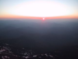
Sunset on the Siskiyou Mountains durning an Angel Flight from Redding to Bellingham.
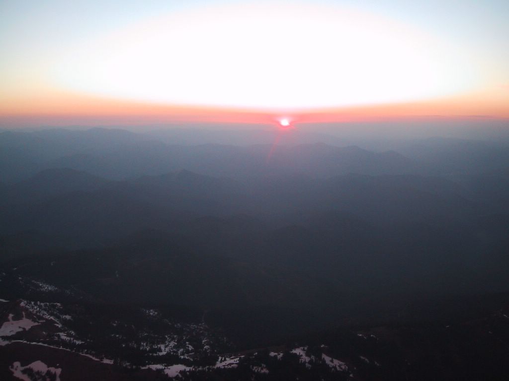
Sunset on the Siskiyou Mountains durning an Angel Flight from Redding to Bellingham.
Saturday, May 07, 2005
Why I Fly (chapter 3)
The weekend had been a busy one. Mowing the lawn (our yard is over and acre, so this can be a major undertaking), visiting mom, biking with the kids, fixing things that had been in disrepair. On Sunday evening I was ready for some downtime – or in my case, uptime.
I drove to the six minutes to the airport, and used my proximity card to drive onto the ramp. I parked next to Regal, got the plane dispatched to me, and climbed in. I had no place I really wanted or needed to go. I took off and climbed to the southwest towards the Bangor Naval Submarine Base.
Around the base is a Permanent Temporary Flight Restriction (TFR) and I’m not making that phrase up. After 9/11 there were four of these Permanent TFRs created in the Puget Sound area. I’m getting off topic here, but these were primarily feel-good measures. Light aircraft are just that – light, too small to cause significant damage on their own, and too small of capacity to carry the kinds of loads necessary to be a threat. Additionally, the radius of the restricted area does not create enough response time to react to a real threat. To pilots they create a maneuvering nuisance. The politicians feel better, and to the two percent of the population that participates in General Aviation is too small of a voting block to be audible voice.
But apparently we are getting through and heard. The Permanent TFRs at Everett, Bremerton, and Indian Island have been change to National Security Areas. Further off topic here, but these are areas that you are allowed to fly in, but they ask you to avoid them, as they can be turned back into TFRs with out warning.
Back to my story. There were some clouds out that day creating a broken ceiling, meaning that between 5/8ths and 7/8ths of the sky was covered by clouds, and the Seattle class Bravo (controlled area around a major airport) airspace extended out where I was headed. Because I was flying Visual Flight Rules (VFR) I could not fly into the clouds, and did not have permission to fly into Seattle’s airspace, I now had three things to weave the plane between.
It only took a few minutes to thread the plane through the corridor that was left open for me, and I maneuvered towards Heron Island where some friends of ours have a house. Herron is a small community that consists of quiet gravel roads, about 100 homes and numerous deer that will eat from your hand. The only way on and off the island is by boat (NO RUNWAY!!!), and the island has a private ferry.
I circled the island a couple of times and then raced the ferry back and forth (surprise, the plane won) several times. When I saw all I wanted to see, I headed a little further southwest to Shelton. Shelton is an excellent airport with a long runway and an active skydiving community. Other than that, there is not a whole lot there.I landed at Shelton and walked around the vast emptiness on my own, there was not another person to be found. What I did find was expansive sheets of concrete in every direction, and a couple of aircraft tied down near weather faded pastel buildings. All ringed by tall fir trees in the distance. If the X-files were still being made, this would be a great setting. If I had to guess, I’d say that is was once and active Army Air Corps base where pilots were trained. While I walked around I imagined the days when this was a busy training field teaming with fighter and bomber trainers preparing those that would be sent into the Second World War (a bit of google searching reveals that it was a Naval Air Station).
The sun was starting to get low in the sky and the air was turning cold, so I decided it was time to head back. I determined that if I filed an instrument flight plan for the trip back, I could avoid the hassles of dodging clouds and airspace. With the sun setting it would be harder to locate ground reference points that I could use to thread through the “bad” airspace, as well as the clouds become harder to see and avoid in the dark.
I called the Flight Service Station from my cell phone, and filed a route that would take me on an “S” shaped pattern from Shelton to the west side of the Puget Sound, up to the Hood Canal bridge, and then across to Paine. I knew when I filed it that my actual routing would be nothing near that. Around the busy airports, the controllers like to vector traffic. The controllers will give each airplane a heading and altitude that will keep airplanes away from one another. But if the radio goes amuck leaving me unable to hear those vectors, having an exact flight plan routing on file creates expectations for the controller to know where I am headed. And as a result, the controllers will clear the area of traffic to keep it away from the out-of-communication airplane.
I took off and contacted the controllers, who immediately set me on a vector straight at Paine, no “S” path for this trip. The course put me into the clouds at 4,000 feet. On this course, I passed through the class Bravo airspace, through the clouds and clear of the TFR at Bangor.A couple miles off the coast of Mukilteo, I was vectored north over the south ends of Whidbey and Camano Islands where I was then vectored east and then south to join up with the Instrument Landing System (ILS) at Paine field. As I descended out of the clouds at 2,000 feet, the airport became visible ahead of me.
Why does this trip qualify as a “Why I Fly” story? Two reasons.
First is the opportunity for me to have alone time. Time where it is just me. I think many hobbies afford this. Time to have personal freedom from external demands. Even in the midst of “avoid this cloud, stay away from this navy base, don’t go near this airport,” the decision is still mine to make, and it is my path to pick to over come the obstacles and how the trip is completed us up to my judgment.
Second is the magic of the instrument flight system. Here we combine big jets at hundreds of miles per hour, with guys that out for a weekend adventure, all operating in the same sight-limiting clouds, separated by rules, procedures, and a voice on the radio watching over us all. When it all works as designed, even adding in human and mechanical failures, we arrive safely at our destination, with runways magically materializing as clouds part revealing the destination. I love the magic of the instrument approach as the clouds clear away, and right there where it is supposed to be is the runway. Pretty cool stuff.
Tuesday, April 26, 2005
Why I Fly (chapter 2)
This installment begins with an admission. I am biased. I think my children are cuter and hold more potential than any other children. Oh, and smarter too. Now that I have that out of the way, my youngest son had a gymnastics meet in Portland Oregon.
The drive to Portland from my house takes three to four hours. The path down I-5 passes through pretty, but repetitive, landscape. (Hey, haven’t we driven past that fir-tree covered hill three times already?) It also takes us through the heart of the Seattle – Tacoma congestion.
Whenever I go to Portland, my preference is always the airplane. I joke that if I have to go south of Seattle and there’s no airport, then I’m not going. I have found the air routing for the Paine to Portland a bit odd, but still better than driving, much of it is spent sending traffic either to the east or west of the busy SEA-TAC airport airspace.
On this trip, it was overcast with forecast freezing in clouds and precipitation, but also clear above 7,000 feet with conditions improving through the day and to the next morning. I filed IFR out of Paine to ARPEE (a fix on the west side of Puget Sound) and then GPS direct to Hillsboro. My plot of the course showed me well clear of SEA-TAC, and then an easy straight line to my destination, climbing to 9,000 feet would put me above the dreary Northwest gray (“grey” for those of you reading from Great Brittan).
The gymnastics meet started at 5:00 P.M. so the forecast fit well into the situation. Go down day IFR in or over the clouds, and back night IFR but with visibility. We had a leisurely lunch, dropped the other three kids off at friends, and went to the airport with plenty of time to load up. Today was a day of not rushing.
Once in the plane, I radioed the tower to pick up my instrument flight clearance. Much to my disappointment, I was given the serpentine route around SEA-TAC, to the Olympia VOR, then on the airway with a peculiar bend in the middle, past my destination to Newburg VOR, and finally back to Hillsboro. Yuck. So much for that fancy moving map GPS in the plane.
I updated the flight plan in the GPS to the new routing, and initiated the communication for taxi and take off. Around 2,500 feet we were met by the overcast. The plane climbed through the clouds as I guided it on course towards ARPEE. At 7,000 we broke out of the clouds to a world of bright white.
To our left the white clouds extended as far as we could see, interrupted only by the mountains tops breaking the flat upper surface. To our right were scattered to broken clouds, giving us an intermittent view of the Olympic Mountains and forests stretching out to the Pacific Ocean.
Mercifully, after passing Olympia we were given direct routing to our destination. Our course carried us past Mt. Rainer, and Mt. St. Helens. Just the top of the crater's rim was peering above the clouds. As we approached the airport we were vectored down through the clouds to the airport, the cloud bases opened up around 3,000 feet so we were given a normal visual landing. Turning us to the left to enter the pattern for the runway landing to the northwest.
Our rental car was waiting for us, and surprisingly for only $20 a day on weekends. It was an easy drive over to the meet with a stop for a light meal. We wanted to make sure my son had enough food in him to get him through the meet, but not so much that he was uncomfortable. We got to the meet early.
The meet went well, and while there I met up with Kale, who lives on an airport, and who had also flown his son to the meet. Kale was in the process of buying a plane that is like ours, but newer and is turbo-charged.
We got back to the Hillsboro Airport and the car return was closed. There was a drop off for the keys, but it also meant my path through the fence back to the plane was blocked. Had I been paying attention, I could have read the code on the inside of the fence for opening the gate and getting back in. Instead I had my son climb the fence and open the gate so we could get back to the plane.
By now the sky had cleared up and with no moon, the stars were the main source of light above. We cruised home in still air watching the meandering line of headlights along I-5. Night flying is particularly beautiful; the predominate visible feature is blackness. The lights of population centers create bright spots on the ground, and then fade out as density decreases in to more suburban and rural areas, roads appear as streams of lights. Where population and water come together, a crisp line delineates the boundary. Rivers cut paths of dark through cities; bays can look like bites out of neighborhoods. Above, the stars appear more brilliant.
The air is usually calmer as well. There is no shaking of the plane, no bumps or burbles in the air, and at times it can seem like the plane is suspended above the ground on a string. The still air and the inky blackness create this sense of isolation. Like being alone, and yet all the rest of the world is visible but only remotely connected.
My routing home was much more favorable. I was cleared GPS direct to ARPEE, and then to Paine. At Bremerton, I was vectored direct to Paine, and I started my descent out of 8,000 feet.
By now the tower at Paine was closed and there was nobody in the landing pattern. I kept my speed up as I approached the airport, and crossed the end of the runway still going over 120 knots. I continued to let the speed dissipate down to landing speed as we floated along the 9,000 foot long surface, finally touching down and turning off about the middle.
That night we were back in the comfort of our own home.
Wednesday, April 20, 2005
Why I Fly (chapter 1)
During long runs of flight training like the one I just completed, I often wonder "Why do I do this to myself?" I don't fly for the money, this costs me. In some cases flying is less convenient, and maintaining the skills requires a further investment of time and money.
My wife, Sandra, has one of those inspirational signs on the refrigerator that says "Life is not made of the number of breaths you take, but of the number of times your breath is taken away." And lately, I've had a string of take-my-breath-away rides that I call "this is why" flights.
The first was to Roache Harbor. It was back in February and we were having a run of early clear spring weather. When it is not raining here, the Pacific Northwest is beautiful. On this day, the blue skies, jagged green islands, and sun dancing off the water combined as an elixir that erases the memory of every gray rain-soaked day that came before it.
A little after noon on Sunday Sandra suggests we take the kids and plane out for lunch. After some debate about where to go, we load up for the 30 - 40 minute flight to Roache Harbor. With the six of us in the plane, my trusty steed (always wanted to use that phrase) climbed easily through the cool air to our cruising altitude of 3,500 feet. The route took us over the Mukilteo Ferry dock, and then along the length of Whidbey Island and then into the San Juans.
We landed at the Roache Harbor Airport, which started out it's life as a road, but when the road was relocated a couple hundred yards to the south, the straight hard surface was made into a runway. The approach cirlcles you out over the water of the Puget Sound and then down onto final approach crossing over the boats moored in the marina, and on to the thin strip of asphalt.
The walk into the resort is about a half mile along a rustic road lined by lush green vegetation. Our senses were assaulted from all sides. The sun casting shafts of light through the trees, the crisp air on our skin, the greens and browns of the forest, punctuated by the bright white buildings, with the scent of the forest mingled with the sea combined into an unforgettable experience.
After exploring around for a bit, we headed to the restaurant. A rustic fish and chips (what else?) place on the dock. Alas, it had just closed, but they referred us to the little grocery store on the same dock, closer to the shore. We bought the kids some sandwiches, chips, and drinks, and sat at the picnic tables near by. While we ate, boaters wandered by with pets, birds arrived and departed, and the sun bathed it all.
When the food was done we explored the moorings, then the parking lot, and the ruins of the old lime mining operation, and then around the coast past the Hotel De Haro and the chapel, then onto the cabins where the kids found a frozen mud-puddle and jungle-gym to climb on and swing. The ice on the mud puddle jolted me in to the realization of just how amazing the day was. Here in the shade, water froze. But in the bright sun, we were warm in our light jackets.
After swinging for a bit, we explored the coast line of the island, discovering kelp, and planks, and rotted out ship hulls, and rusted steel boilers. There were rocks to climb, trees to swing from, and sea critters to be chased from under rocks.
When I started to corral the kids back towards the airport, they nor their mother were none too happy. This was a day that wanted no end.
The plane carried us back into the sky, but on this leg we stayed low as we flew around the coastline of the island, scanning the waters for whales or other interesting sea life. Instead we found only the patterns and colors that showed the water's depth and flow.
The trip back home was peaceful. I let my oldest daughter guide the plane, with me making slight corrections when necessary to keep us headed towards the big runway.
We were back in time for the kids to watch a movie, read for a bit, and then drift off to sleep.
Without the plane, just the trip to the San Juan's is nearly a half day event, we were able to go there and back -- on a moments notice -- and make memories along the way.
Saturday, April 16, 2005
new wifi router.
Several years ago I was using wingate to connect multiple computers to the internet and, I decided I needed a firewall, and better system than leaving one computer on all the time. So I bought an SMC Barricade 802.11b wireless router. It has been pretty much trouble free.
I'm sort of a late adapter, using the "if it works, don't fix it" theory. So I have not been in a rush to upgrade to "g," and with "n" just around the corner (there is always something better), I've been stalling. My SMC died last week, so time to upgrade. Several folks I know use linksys. They really like them. Some of them are biased as they work for Cisco, which owns linksys. My three experiences with the linksys routers have none gone well.
Not sure why I didn't look for another SMC. It was a good product. On a side note, the first NAT router I ever installed was a macsense. And it is still running today, although the owner is starting to talk about wireless.
Another friend has a netgear, and it didn't seem all that bad. So I used a gift certificate I had from work to upgrade.
While I was waiting for it to arrive, I attempted to resurrect my SMC, resetting it to factory defaults. I also created a profile on my laptop for an unsecured connection so I could hook up to it. Bang, I'm connected up right away. I enter the URL to the router management page and type in the default password. At this point I'm thinking that I just wasted my money on a new router, when the old one still works.
When the router config page comes up, it doesn't say SMC, it says linksys! Huh? What's going on? It took me a few seconds, but it turns out that my router was still not working, but my neighbor's across the street was. And it was totally unsecured, right down to the admin password having never been changed.
Now this worked out pretty good for me because I could stay connected to the net until my router came. Whoo Hoo!!!
My netgear showed up and I quick like read the install directions (yeah right!), ok browsed the install directions, which walked a new user through the security configuration process. Very handy.
Anyway I ignored them and set it up the way I wanted it, and in 20 minutes I was all up and running again. I also went and confessed to my neighbor, and offered to help him secure his. He politely declined, and said he was going to call linksys and have them walk him through it.
But if you are reading this and you don't know if your wireless router is secure, you need to spend some quality time with the instructions.
Sunday, January 23, 2005
Talk to me.
Adam hooked me up with Skype. This is a very cool and useful tool. I describe it as Instant messenger (IM) meets Voice Over Internet Protocol (VOIP). Previous voice messengers I had tried worked similar to the Yahoo! client. These were push to talk or voice activated simplex transmissions. Plus they would drop portions of a conversation.
But Skype is different. Full duplex, works on my low power laptop over my wireless home network, and onto my Verizon DSL connection (the irony there is not lost on me). My laptop's microphone is too close to the speakers, so I get a audio feedback squeal if I am not using headphones.
I use Skype regularly to talk co-workers also using Skype in India and Japan, sometimes for hours, and -- this is the best part -- for FREE! I love the internet. Call me some time, my user id there is Roger.Weber.
The downside of Skype is that they do need revenue, so if I want to call a regular phone, I have to pay.
Considering Adam works for google I found this article quite fascinating. Is this what google Kirkland is working on? And the article implies that google's VOIP will be free.
I love the internet.
Friday, January 21, 2005
More COM violators!
Today's COM violator is JDOM. A customer had indicated that while editing a file in the WLW IDE, much of the file got red-squiggles -- a sign that there are syntax errors of some sort. Those of you that program or use MS Word would recognize them right away. We had the customer send in the app so we could reproduce the trouble.
Turns out the customer was attempting to use a later version of JDOM. We also use JDOM, as is, and the customer's use of the new one caused the IDE to tag legitimate methods as invalid.
I'm thinking of requesting a new enhancement for the server. One that would separate the customer's classpath from the server's class path. A special kind of class loader could do it.
Just a thought.
Sunday, January 16, 2005
Finally!
For quite awhile now, I have been working on my Commercial Pilot's License. The reasons why are not important. What is important is that today, I passed.
It all started yesterday. I had my usual inability to sleep. My 3 year old, Molly, awoke early so I collected her and brought her up to my bedroom. She snuggled into my side and began to snore. How does something so small make so much noise? I finally just got out of bed since the chance of sleeping had been reduced to zero. Molly snuggled up with Sandra, her small round face still generating the rhythmic low growl of a snore.
By 9:00 AM I was in the office of Colonel Bob, a retired USAF pilot. I cannot improve on Tom's description of Col. Bob, who says "Bob is a trim, older man. His appearance and his office scream efficiency." I have great admiration for Bob, and wanting to gain his approval creates for me much anxiety.
We had the conversation that I expected, and I messed up on a couple of questions. Nothing disqualifying, but yet Bob busted on me for them, he's right of course. For instance a metar that reads -FZRAPL does not mean "subtract freezing apples" but rather "Light Freezing Rain and Pellets." I also should have known that the Cessna 177RG that I was using for the test was made in 1976 before the requirement for an Approved Flight Manual, (March of '78), and thus did non have one.
Around noon we broke for a quick lunch, after which I called the Flight Service Station, which repeated the "-FZRAPL" forecast, but did not seem too concerned about it. In fact the briefer indicated I would most likely be fine. We loaded into the airplane.
Bob asked for a soft-field take off, which went pretty good as we broke ground and headed for the imaginary flight plan. The plan called for a climb to 9,500 feet to cross over mountains on the way to Yakima. Due to the deteriorating conditions, we were unable to get much above 3,000 feet, and never into the winds that would have made the 15 degree wind correction angle necessary. I had backed up my course with a radio navigation aid, so I intercepted the 106 degree radial and headed south-east. Bob asked if we were on course, and I said we were, so he asked how I knew. I pointed to the OBS. He spun the dial, and told me to keep flying. I put the compass on the planned heading and continued to fly.
By that time so much was different from "planned" that I had left the cowl flaps open. And they stayed open far too long afterwards.
A few minutes later Bob asked again if we were on course, and where Duvall was. DUVALL??? Who knows where Duvall is to begin with? I certainly don't. There is plenty I do know, but the location of Duvall is not one of them. After several uncomfortable moments of searching the map, and looking at roads, and looking at the map, and looking at roads, I found that Duvall was to the left of my nose, and that the flight plan showed that it should be to the right of my nose. I found a prominent bend in the road that I could use to reset my course and flew to it putting me back on course.
At that point we decided the cross-country was done and I was to divert to the Monroe airport. We broke off turned north and made tracks for Monroe. When I spotted the airport, we headed out for the upper air work. Without a lot of upper air available, Bob opted for a more specific set of maneuvers. Most went well until we got to the one that is the easiest, the steep-bank turn. This one went horrible. Altitude and airspeed departures on both sides of the turn. Bob covered up the attitude indicator and the compass and made me do it again. This one went much better.
From there we went to Monroe to perform a short field landing, using the threshold as the aim-point. I was a few feet past the threshold but still managed to stick the plane on the on the first half of the numbers. Maybe 20 feet past. I was pleased.
At the other end of the runway, I turned around for the short field takeoff, back into the sky the plane went.
We climbed out looking west for the impending -FZRAPL but it was still looking ok. I selected a railroad track to perform an eights on pylons and entered my first turn to the right. As the nose of the plane rotated through to the west, I saw that the visibility had dropped. Bob said we should think about heading back. I swung the plane around the next pylon to look up at the visibility rapidly going from bad to "we should not be up here." Bob pointed out that the water on the wings and windshield had stopped moving. It had froze. I hit the pitot tube heat and had Bob turn the defroster on full.
I broke off, Bob tuned the radio to he Automated Terminal Information System, and I called up Paine Tower to ask about the current conditions. Forward visibility continued to drop, and the tower reported freezing rain and ice pellets. It was 2:00 P.M. Exactly as forecast.
I told the Paine Tower we were diverting to Harvey, which I could still see just behind me. Now ice was accumulating on the wings. I dropped to pattern altitude and held on to my airspeed. On final I was still at 10 kts above normal approach speed and high to compensate for the accumulating ice.
The landing was smooth, and on roll out I hit the brakes to no avail. And Bob tells me I am left of centerline. D'oh! I know this is one of his pet peeves, but dang, I'm just glad to be on the ground. With all the power off and marginal breaking I roll the plane to the end of the runway, and taxi back to parking. There was about an eighth to a quarter inch of clear ice on the leading edge of the wing when we got out. The day's flying ended there
We met back at Paine today at 9:00 AM. One of the Regal's flight instructors drove us out to Harvey to retrieve the plane. The forecast was for improving conditions and the ceilings at Paine had gone up to 1,000 feet. A normal take off at Harvey with intent to fly back to Paine for the power-off 180's and to be done.
With the plane in the air, we found the ceilings at Paine were back down below 1,000 feet. I requested a special VFR to get back. Since someone else had beat me to it, the tower instructed me to remain out side of their airspace and I would be given clearance in about seven minutes. I could tell that I was not going to be able to make repeated touch and goes at Paine, so I canceled the Special VFR request and decided to do the power off 180's a Harvey instead. My first came up short, and I had to run up the engine to hold the plane above the power-lines that border the north end of the field, and turn the landing into a soft-field instead.
The next time around, the other plane in the pattern was flying a very WIDE down-wind and base leg, necessitating me to make two 360 degree turns to assure adequate spacing. I headed for the power off, and ended up high on final, with full flaps and an aggressive slip, I flared and floated. I thought too far.
It was then we headed back again for Paine. We got the special right away. Staying clear of the clouds required me to fly at 600 feet above the ground as I lined the plane up for the runway. Bob asked for soft-field further down the runway. I was glad to be back over the runway with the end of the ride in sight.
After an uneventful landing we taxied back to Regal where I shut down the plane. Bob turned to me, put out his hand and said "Well, I think you earned it."
I think I'll wait a while before tempting fate any further. To this I'd like to add a special note of thanks to Terry and Jerry who drove us between airports, Chuck who did the most of my training, Patty who finished it off while Chuck was recovering from surgery, and most of all Sandra who has supported me FAR to long.
Monday, January 10, 2005
Don't violate COM
I remember back in the good ol' days when I was an application developer and I was learning to write in VB. Since most of my time was spent in RPG and COBOL, I didn't do all that much object oriented (OO) programming, but one day my co-worker, Margo, admonished me "Don't violate COM!" Since I did not know what COM was, I was fairly certain that I had not violated it.
Later I learned that COM had something to do with an Object, and to violate it meant to change how it was interacted with, like adding or removing public methods. Since I was still on my first OO project, and had never released the object before I remained certain that I had not violated it.
So now that I am responsible for every thing that happens to WebLogic Workshop (WLW) after it goes to GA, I REALLY get what "Don't violate COM" means. You see, WLW uses a couple (or so) open source products. The two I hear about the most are log4j and XmlBeans.
I hear about our use of log4j with great regularity. And the reason it that log4j violates COM. Here's what happens. Lets say that we ship log4j version A, but our customer wants to deploy a packaged J2EE application that uses log4j version B. If all of version B's interfaces worked like version A's interfaces (plus what ever improvements), life would be good. But since it does not, replacing version A with B results in failures a plenty in the server. Attempting to use version A with the packaged product causes failures in the application.
bummer.
So what is an open source consumer to do?
David Bau spent a bunch of time writing about this in his "Theory of Compatibility" series, parts one, two, and three. Now I'm a big fan of David's, but I think this representation-vs-interface debate won't fix a lot of things. It won't fix C++, or Java. Both of these are interface level compatibility issues. And it does not fix all the software out there. The best fix really is to "Don't violate COM." Yet we all know it is harder to get the cat back in the bag than it is to let it out. In log4j's case, the cat is already out.
Best Practices
If you are writing and contributing to an open source project, DON'T VIOLATE COM! Add a test to your test suite that is a static .jar, and from it run tests against the .jar you just created. If the tests fail, try again. You are probably about to make your consumers have a very bad day.
If you are a consumer, consider repackaging. Here's what we do with XmlBeans (not sure why we did not do this with log4j). We take the XmlBeans source, and scan all of the "org.apache.blah" and replace it with something like "com.bea.blah. This allows a customer to use what ever version of XmlBeans with out interfering with the one we use.
Subscribe to:
Posts (Atom)